


Hail, thunderstorms, unusual chill: sudden cold front arrives in Hungary – here’s what to expect this week

After weeks of scorching heat and a virtually rainless June, relief has finally arrived in Hungary in the form of a cold front. The good news? It’s bringing not only cooler temperatures but also much-needed rainfall. For Hungarian agriculture—as well as home gardeners across the country—rain has been sorely missed. Of course, when cold air follows such intense heat, sudden storms, tennis ball-sized hail, and damaging wind gusts are almost inevitable. Here’s what to expect.
Significant cooldown ahead as cold front moves in
According to the state-run HungaroMet, the upcoming weather pattern is fairly straightforward: a cold front will sweep through, bringing cooler and wetter air in several waves. While eastern Hungary may still experience temperatures above 30°C (86°F) today, the west is already preparing for a substantial drop. Travelling across the country today could mean encountering a temperature difference of up to 10°C—moving from summer into spring, or vice versa, depending on your direction of travel.

- The country is bone-dry, extreme heat persists, river levels on the Tisza and Danube are at record lows, and animals may be forced to migrate — read more about the past month’s challenges HERE.

By Wednesday, temperatures could plummet by as much as 15–20°C (27–36°F) compared to today’s highs—a dramatic shift that may pose health risks for those sensitive to sudden changes. Symptoms such as dizziness, headaches, poor concentration, and circulatory problems may occur. In fact, HungaroMet reports that by midweek, the highest temperatures in many areas may not even surpass Monday morning’s early lows. In some regions, Wednesday’s daytime highs will be lower than those early morning readings.
Still, cooler weather doesn’t mean lower UV exposure. UV rays will remain just as strong, so it’s advisable to avoid prolonged sun exposure between 11 a.m. and 4 p.m. If you must be outdoors, use sunscreen and wear appropriate clothing and a hat.
Hail and storm-force winds to accompany long-awaited rain
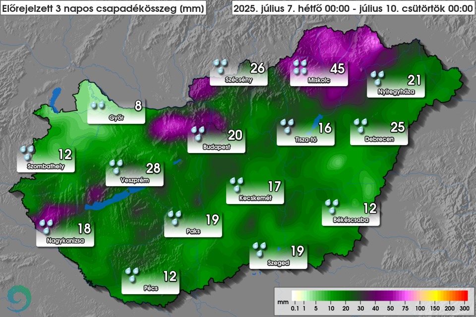
For both large-scale agriculture and home gardens, the coming days will bring welcome rain. Heavier rainfall is expected today, particularly in western regions, but by tomorrow it should spread to most areas and persist through Wednesday in the north-eastern and eastern parts of the country. According to HungaroMet, places such as Veszprém could receive up to 28mm of rain over the next three days, while even the lowest forecast for Győr stands at 8mm.
- Budapest’s dreaded Hunger Rock emerges for the second time in a year
Rainfall forecast for the next three days:
Citing HungaroMet, ATV warns that wind gusts could reach 90–120 km/h (56–75 mph) in several areas today. The cold front may also bring hail, with some pieces as large as tennis balls.
Here’s the forecast:
- Find more weather-related articles HERE.
To read or share this article in Hungarian, click here: Helló Magyar